Mining

Monitor performance.
Validate build quality.
Keep access corridors open.
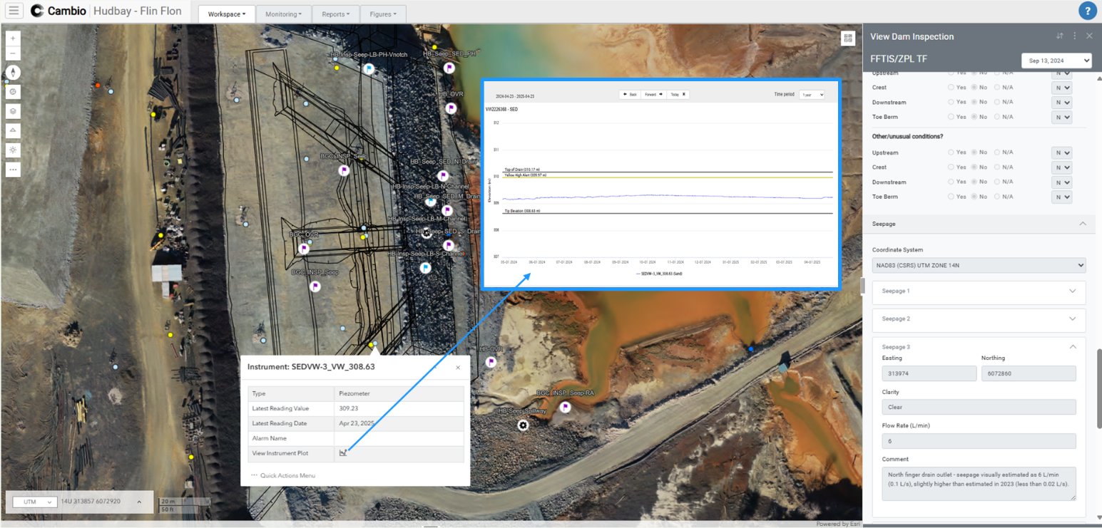
Laptop screen showing Cambio software with elevation profile tool overlaying an aerial map of a construction or mining site, displaying elevation data and borehole annotations.
Earth sciences play a critical role in reducing delays, tracking compliance, and monitoring performance.
Tailings storage facilities (TSF), mine infrastructure, and access roads generate mountains of data—baseline studies, inspections, instrumentation, remote sensing, and routine reports. As this knowledgebase grows, from prefeasibility to closure, so does the pressure to catch performance trends early, monitor construction progress, and demonstrate compliance across multiple sites and evolving standards like GISTM.
COMMON CHALLENGES
Vast amounts of underutilized data scattered across disconnected systems, contractors, and consultants.​
Evolving regulatory requirements (e.g. GISTM) demanding greater transparency and documentation.
Delays in decision making caused by slow issue verification and field-to-office communication.
Maintaining program continuity through staff, EoR, or contractor changes.
Cambio™ provides measurability for program effectiveness and operational efficiency
Are you tracking and verifying potential issues early enough to prevent costly delays?
Are your TARPs consistent across sites and teams?
Can you prove adherence to standards across every facility and site?
Did you place the right material, in the right location, and to specification and design intent?
What happens if your key people leave—or you change vendors, contracts or consultants?

We take away the guesswork

plus sign symbol
Create a digital geospatial knowledge base that can be accessed across the project lifecycle
  • Site-wide view across TSFs, pits, and haul roads
  • Change detection from lidar, InSAR, and drone surveys
  • Access to historical information, field, site characterization, and real-time monitoring data  
  • Visualization and analytics tools to strengthen collaboration, onboarding, and communication
plus sign symbol
Improve field-to-office communication and collaboration
  • Dynamically view field data alongside key project data
  • Mobile tools to geospatially reference quality assurance and control data, field observations, and photos
  • Shared dashboards for engineers of record (EoRs), contractors, and owners to track progress and updates
plus sign symbol
Reduce costly delays and respond faster with instant access to all site data
  • Real-time monitoring data from piezometers, inclinometers, pond levels, weather data
  • Change detection to validate movement
  • Drone imagery, photographs, and inspection history for added context
  • Automated alerting based on site-specific trigger levels for early warnings
plus sign symbol
Preserve program continuity and meet evolving compliance standards
  • Centralized repository of inspections, instrumentation, designs, and construction records for smooth handovers across EoRs, contractors, and mine phases
  • Support for evolving disclosure requirements, including GISTM
  • Tabular and map-based tools for audit-ready reports or visual review sessions
"The ability to connect historical inspections with live observations has transformed how we understand and act on changing conditions at site."
Brad Russell,
Principal Geotechnical Engineer & Engineer of Record for Hudbay, BGC Engineering
our RESOURCES
Related Articles
ALL ARTICLES
Enhancing Dam Safety Inspections with a Digital Knowledge Base: Lessons from Hudbay
At Hudbay’s Flin Flon Tailings Impoundment System (FFTIS), BGC Engineering and Hudbay partnered with Cambio Earth to explore how a geospatial digital knowledge base can transform dam safety inspections (DSIs).
arrow rightarrow right
From Siloed Data to Continuous Insight: Real-Time Monitoring Transforms Tailings Management (Part 1)
Mine owners, Engineers of Record (EoRs), and geoscientists are embracing integrated instrumentation and geospatial tools to break down data silos. The result is real-time situational awareness, a dynamic digital knowledge base for data-driven decisions, and safer, more efficient tailings operations—delivering continuous insight from prefeasibility through construction and into closure.
arrow rightarrow right
From Siloed Data to Continuous Insight: Real-Time Monitoring Transforms Tailings Management (Part 2)
In Part 1, we explored how siloed data can undermine tailings storage facility (TSF) monitoring, and how platforms like Cambio are enabling continuous insight through integrated, geo-referenced digital twins. Now in Part 2, we focus on implementation—what it takes to modernize your monitoring workflows, and the real-world results that follow.
arrow rightarrow right

Unlock every report to speed up decisions, reduce stoppages, and set projects up for long-term stewardship.