Transportation

Improve operational efficiency.
Strengthen regulatory compliance.
Prevent geohazard-related failures.
Laptop screen displaying a remote sensing map with elevation profile graph and selectable LiDAR survey layers.
Earth sciences play a critical role in monitoring ground hazards and climate-driven deterioration.
Building and operating resilient highways and railways is a long game, especially as conditions evolve over time and assets are exposed to landslides, floods, earthquakes, and extreme events. Cambio™ is used by state DOTs, rail operators, and national agencies to detect slope, drainage, and permafrost issues early—reducing closures, delays, and emergency costs.
COMMON CHALLENGES
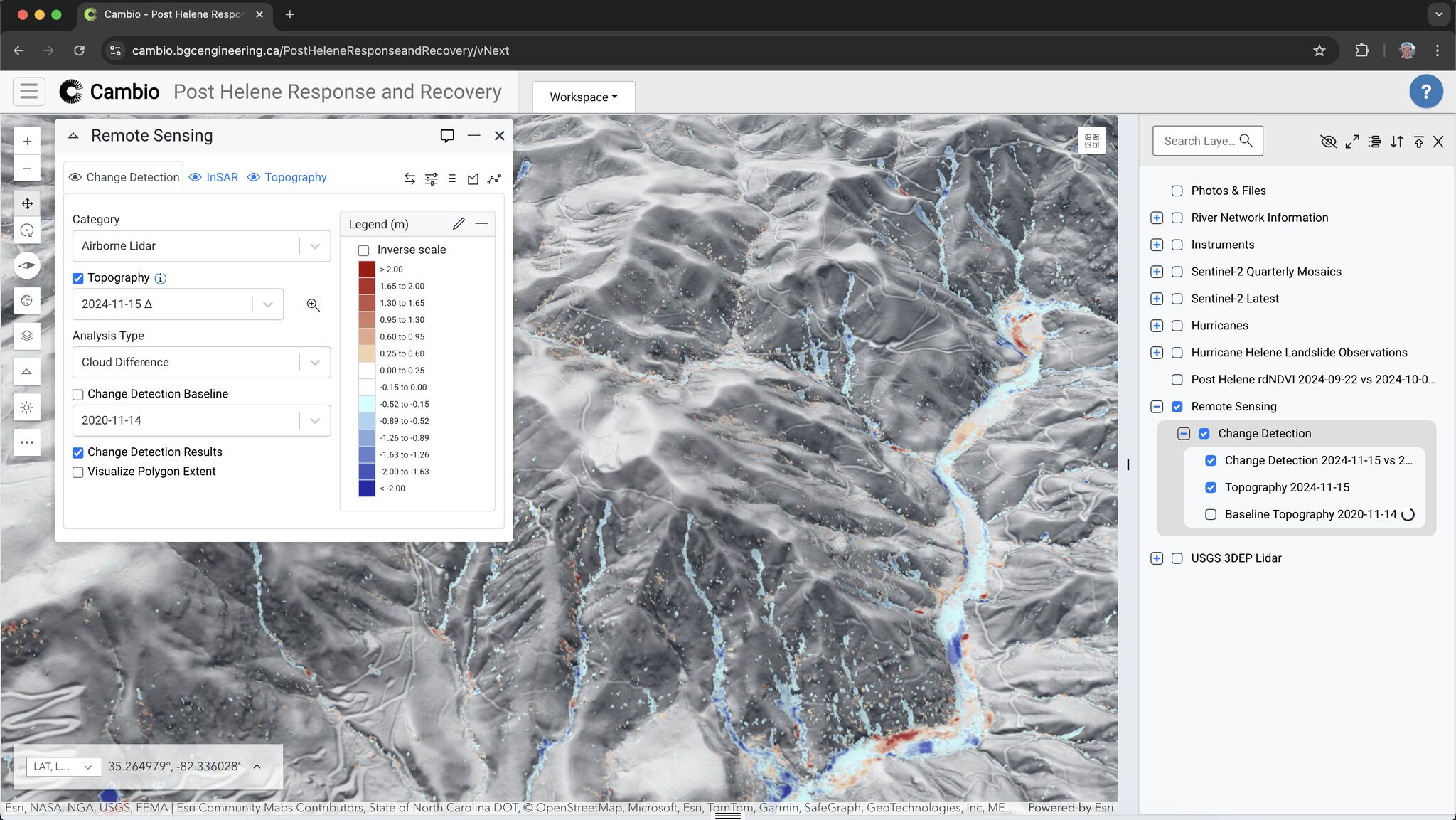
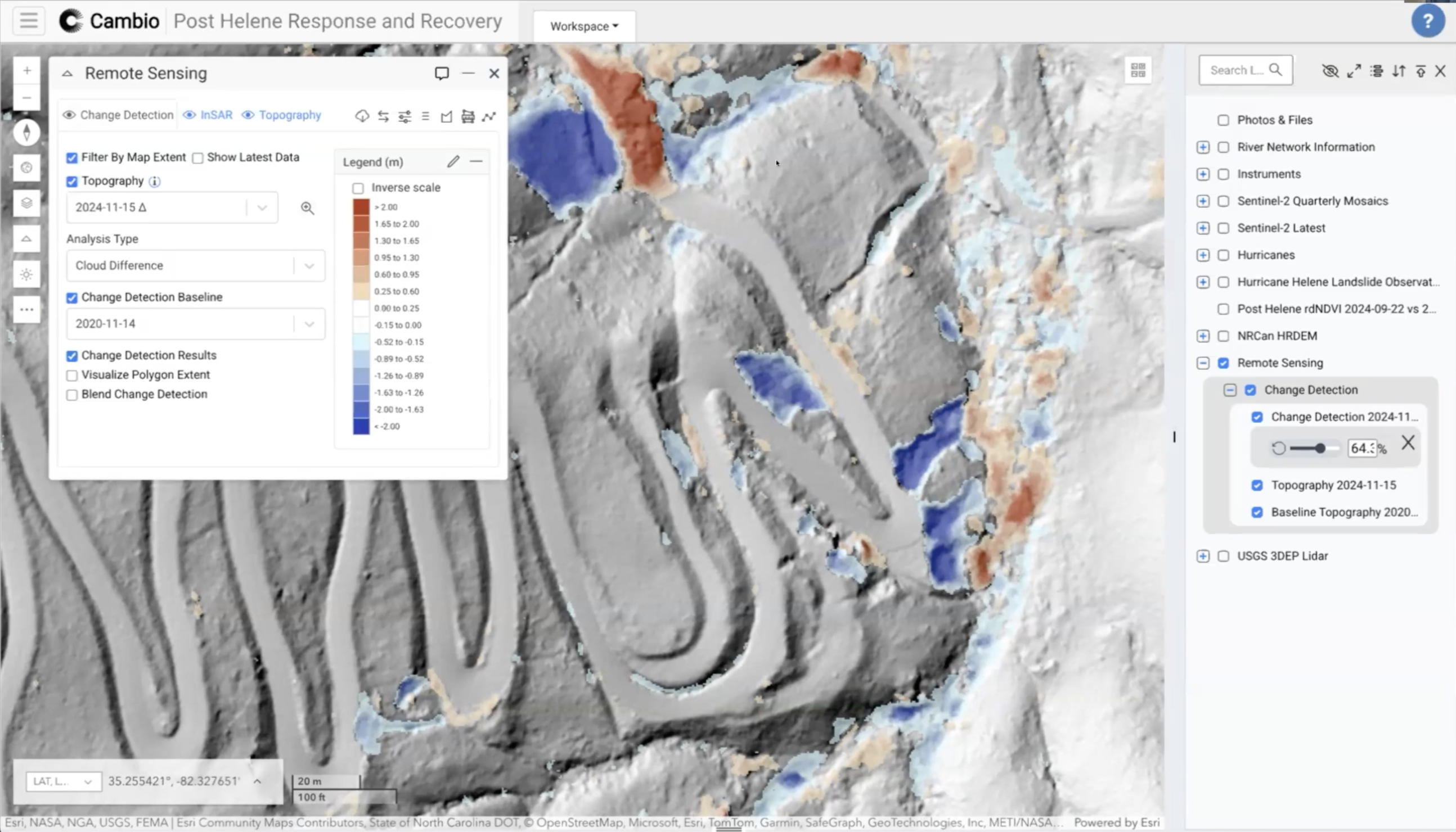
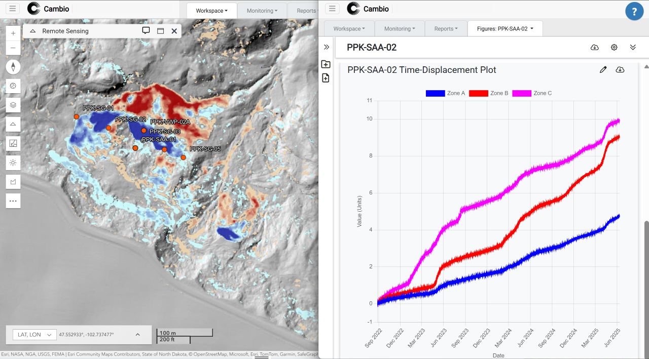
Underutilized data from lidar, InSAR, instrumentation, inspections, and weather across disconnected systems.
Evolving regulatory requirements demanding greater accountability, transparency, and documentation.
Resource constraints caused by tight budgets and limited crews for inspections and maintenance.
Increased exposure to climate volatility with pressure to maintain service during extreme events.
Cambio provides measurability for program effectiveness and operational efficiency
Are you focused on the right segments and assets?
Are you catching movement changes or drainage issues before they cause closure?
Can you clearly explain and justify mitigation priorities to leadership?
Can you prove inspection consistency across crews and contractors?
Are you maintaining defensible records for emergency funding claims?
What happens if your key engineer or project lead leaves mid-program?

We take away the guesswork

plus sign symbol
Detect slope, drainage, and surface stability issues before they disrupt service
  • Lidar/InSAR change detection for slopes, embankments, and drainage systems
  • Inspections, instrumentation readings, and imagery feeding into automated risk models
  • Historical records to confirm whether issues are new or recurring
  • Alerts triggered by rainfall, snowmelt, or movement thresholds
plus sign symbol
Respond faster to extreme weather and seasonal events
  • Live overlays for rainfall, snowpack, streamflow, earthquakes, and wildfires
  • Pre/post-event change detection to confirm impacts
  • Risk recalculations to reflect changing conditions after events
  • Event-triggered workflows for rapid hazard reassessment
plus sign symbol
Streamline inspections with standardized processes and automated assessment  
  • Built-in inspection forms for slopes, washouts, culverts, debris flow crossings, and rockfall sites
  • Automated hazard ratings using embedded probability and consequence models
  • Centralized inspection records with photos, measurements, and comments
  • Consistent scoring across crews, regions, and contractors with inspection approval workflow for senior review
plus sign symbol
Optimize budgets with high-confidence desktop inspections in challenging and remote terrain
  • Before/after change detection to validate stability from the office
  • Lidar, InSAR, photogrammetry, and instrumentation trends for detailed monitoring
  • Weather and environmental data to target inspections to the most at-risk sites
  • Remote verification of issues to reduce unnecessary mobilizations
"We could see slides moving in real time and set up data alerts. One of the Shape Array (SAA) sensors triggered on our fastest-moving slide which helped us avoid that zone in our alignment planning."
Eric Lim,
Senior Geotechnical Engineer,
Western Federal Lands (FHWA)
our RESOURCES
Related Articles
ALL ARTICLES
Rapid Lidar Deployment for Post-Hurricane Disaster Response: A Case Study
This case study examines the potential implementation of Light Detection and Ranging (lidar) technology in rapid disaster response following Hurricane Helene in September 2024.
arrow rightarrow right
Case Study: Rebuilding Yellowstone — How Real-Time Instrumentation in Cambio is Guiding Resilient Infrastructure
In June 2022, a catastrophic rain-on-snow event swept through Yellowstone National Park, washing away critical roads, severing community links, and forcing engineers to rethink what it means to rebuild in landslide terrain.
arrow rightarrow right
Cambio Earth Wins 2025 CIO Award for AI Innovation in Geohazard Monitoring
We’re humbled to have been recognized for our groundbreaking work in applying artificial intelligence to geohazard monitoring and risk analysis.
arrow rightarrow right

Unlock every dataset and report to improve operational efficiency, strengthen regulatory compliance and prevent failures.