Case Study: Rebuilding Yellowstone — How Real-Time Instrumentation in Cambio is Guiding Resilient Infrastructure

In June 2022, a catastrophic rain-on-snow event swept through Yellowstone National Park, washing away critical roads, severing community links, and forcing engineers to rethink what it means to rebuild in landslide terrain.
At the first-ever Cambio Transportation User Group Lab, a virtual room of DOTs, federal agencies, and transportation experts gathered to hear how the team behind the North Entrance Road reconstruction is using instrumentation data inside Cambio to make smart, risk-informed decisions—fast.
From Remote Sensing to Real-Time Sensors
Scott Anderson of BGC Engineering opened with the backstory: originally, Cambio was introduced to contextualize InSAR data as part of a route study on Yellowstone’s northeast corridor. At the time, only a single snapshot of lidar was available—enough to show the morphology of two large landslides, but not whether they were actively moving.
Then the flood hit.
Suddenly, the focus shifted to the North Entrance Road, the park’s main artery between Gardner and Mammoth. That corridor was devastated—and with limited time and high public urgency, the team had to move fast.
Surrounded by Slopes, Racing the Clock
Eric Lim, Senior Geotechnical Engineer with Western Federal Lands (FHWA), was on-site immediately after the flood. The canyon road was obliterated. A temporary detour was carved along the original Gardner Road, high in the hills—through a landscape dominated by active earthflows and slumps.
“Everything west of the canyon is basically old earth flows and mapped landslides,” said Lim. “We didn’t know the new alignment yet, but we had to get instruments in the ground right away.”
The team deployed a suite of instruments across three geohazard zones, including ShapeAccelArrays, slope inclinometers, and vibrating wire piezometers with one goal in mind: gather movement and groundwater data as quickly and continuously as possible.
Why Real-Time Matters
Thanks to cellular coverage near Gardner, the instruments were wired into real-time telemetry systems that streamed directly into Cambio. This allowed the team to monitor slope behavior continuously—no waiting for seasonal field visits or static snapshots.
“This was a huge advantage,” Lim noted. “We could see slides moving in real time and set up data alerts. One of them triggered on our fastest-moving slide—SAA 2210—which helped us avoid that zone in our alignment planning.”
Among the most critical findings? A 190-foot-deep shear plane, actively moving—precisely where InSAR had also flagged instability. Cambio helped align these multiple data streams into one coherent picture, enabling the team to confidently exclude high-risk zones from reconstruction.
Bringing Instrumentation to Life with Cambio
Cambio helps geotechnical teams manage complex instrumentation programs by unifying data, context, and decision-making tools in a single platform. In projects like Yellowstone, this means engineers can:
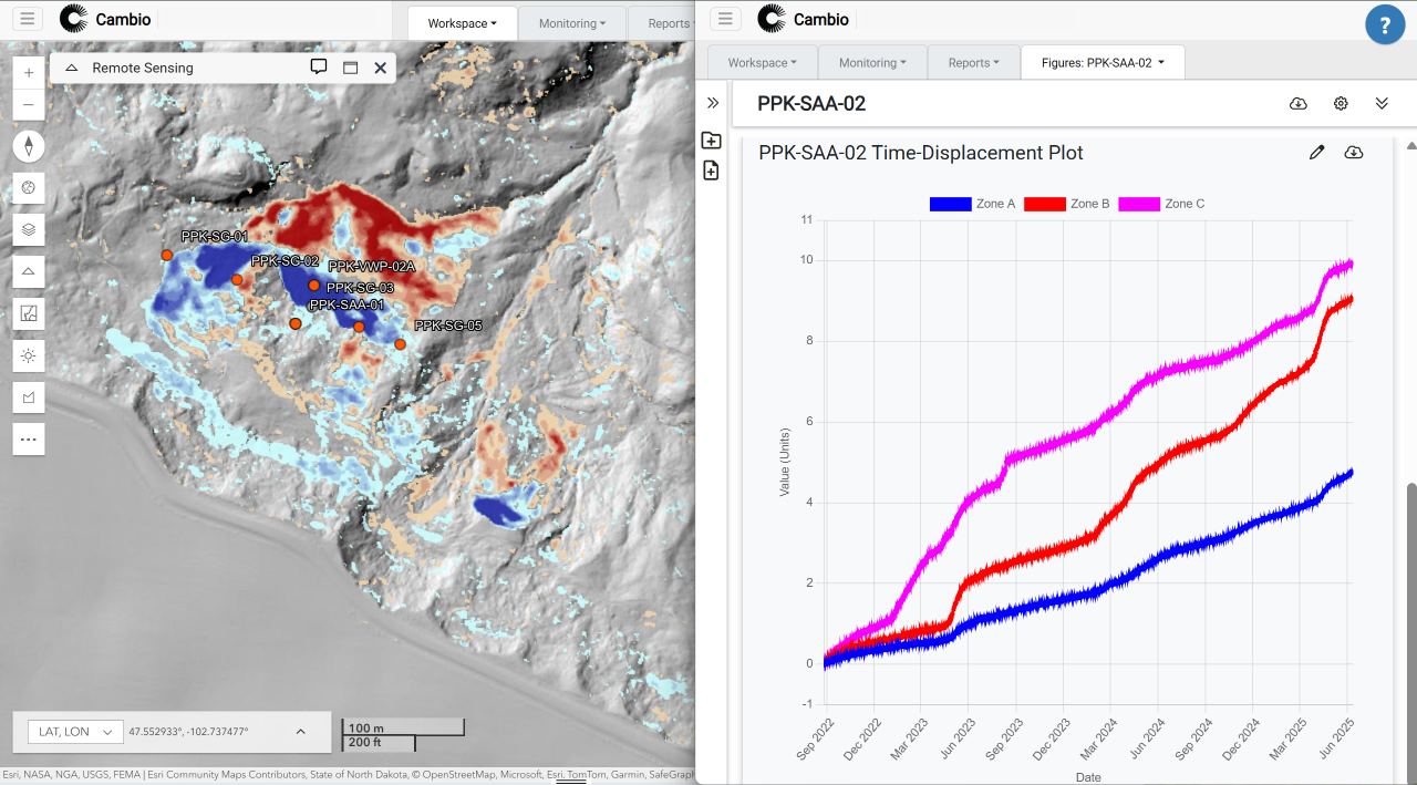
- Visualize alarm states at a glance with plan views that color-code instruments based on threshold breaches—making it easy to spot where intervention is needed.
- Review displacement plots alongside borehole metadata, providing a clear vertical profile of how different layers are behaving over time.
- Use custom annotations to mark materials, movement zones, or depth intervals—helping teams interpret acceleration patterns in both spatial and time-displacement plots.
- Access critical documents directly in-platform, including borehole logs, field photos, installation records, and calibration files—each tied to its associated location or instrument.
These capabilities help teams move quickly from data collection to insight—supporting everything from design decisions to ongoing risk monitoring. Whether data is streamed from the field in real time or uploaded manually, Cambio ensures it’s accessible, interpretable, and actionable across all stakeholders.
“This is the platform I always wished I had when I was in the field,” said Jason Waldick, a former geotechnical engineer turned software builder. “Now we’re making it for others.”
Cambio supports both real-time and manually collected data, and Yellowstone’s monitoring program uses both approaches. While North Entrance sensors stream live data, the more remote Northeast Entrance corridor is monitored using manual slope inclinometer readings—uploaded and visualized in the same environment.
Final Thoughts
Cambio’s role in Yellowstone highlights how transportation agencies can use flexible instrumentation management to adapt, respond, and build smarter. Whether responding to natural disasters, navigating slow-moving landslides, or working with decades of legacy data, Cambio helps turn geotechnical complexity into actionable insight.
.svg)

%20Large.jpeg)

.png)