.svg)
Enhancing Dam Safety Inspections with a Digital Knowledge Base: Lessons from Hudbay
Introduction: Why Now?
Tailings dam safety is under more scrutiny than ever. Since the release of the Global Industry Standard on Tailings Management (GISTM) in 2020, operators are required to maintain an interdisciplinary knowledge base that’s up-to-date, accessible, and shareable across teams. For many, this has meant moving away from static reports and fragmented GIS files toward integrated, real-time systems.
At Hudbay’s Flin Flon Tailings Impoundment System (FFTIS), BGC Engineering and Hudbay partnered with Cambio Earth to explore how a geospatial digital knowledge base can transform dam safety inspections (DSIs). Their case study was presented at Tailings 2025 in Santiago, Chile in September 2025.
The Challenge: Paper Trails and Data Silos
Historically, DSIs relied on paper forms, static maps, or isolated digital tools. While digital forms improved efficiency, they often didn’t connect to broader site datasets—especially in offline environments.
This created three key challenges:
- Precision & Traceability – Field notes often lacked geographic context, making it harder to compare changes over time.
- Communication Gaps – Photos and notes were detached from spatial context, leaving owners and EoRs with limited insight.
- Lost Institutional Knowledge – Decades of inspections, photos, and site records risked being underutilized or forgotten.
The Solution: A Digital Knowledge Base with Cambio
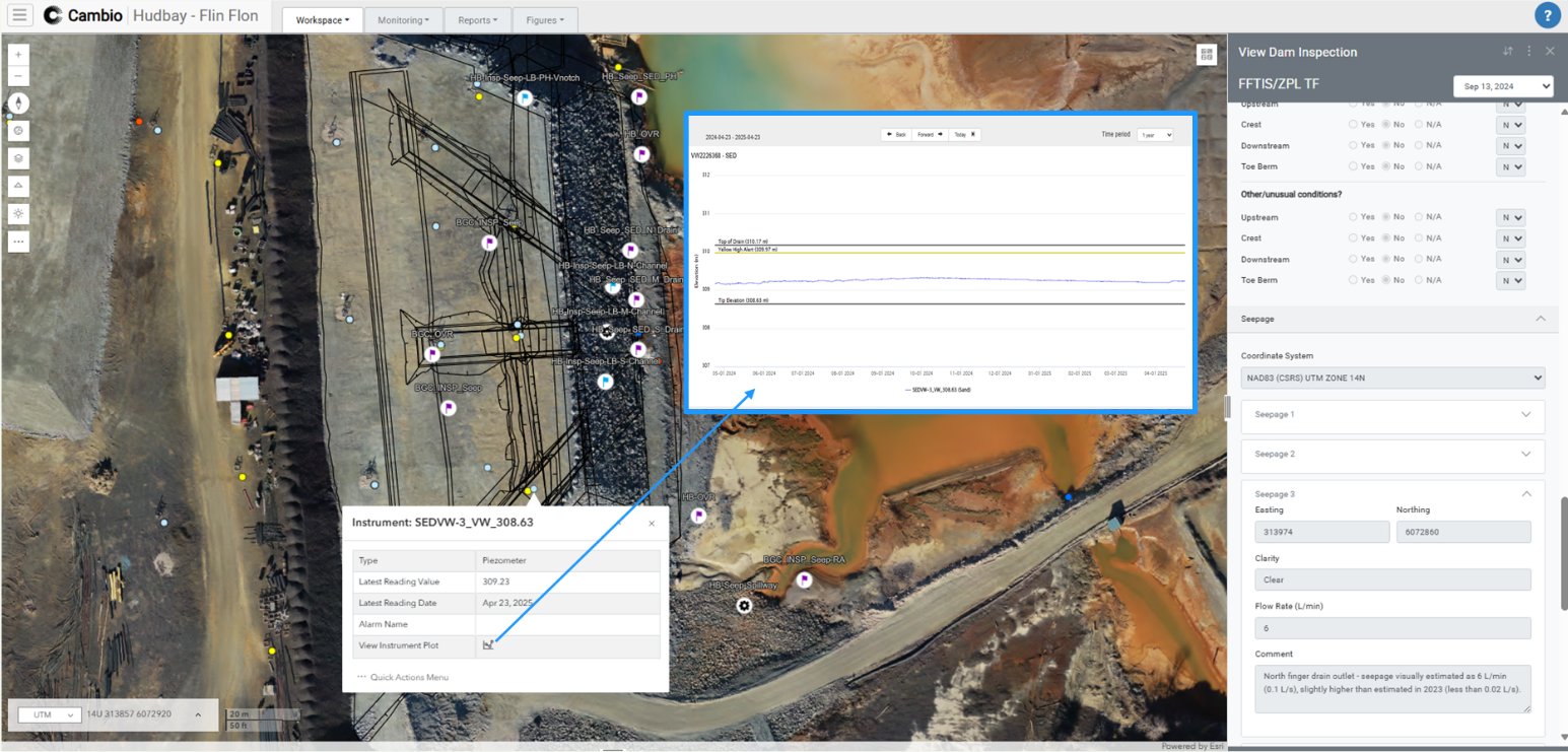
Hudbay and BGC deployed Cambio™ as a centralized, geospatial knowledge base for DSIs at FFTIS. Here’s how it changed the process:
- Observation Points: Inspectors could see flagged points on a live map, view historical photos and comments, and add new observations. Over time, this builds a visual timeline of conditions at specific locations.
- Standardized Inspection Forms: DSI forms in Cambio are digitally generated to ensure consistency and improve efficiency as they are saved directly into the central knowledge base.
- Integrated Data Layers: Inspectors could access design lines, instrumentation data, borehole logs, and historical imagery side by side in the field.
- Collaboration Workspaces: Teams created and shared “workspaces” linking observation points with supporting data, ensuring everyone—from inspectors to owners—was literally on the same page.
The Impact: Safer Dams, Smarter Teams
By digitizing DSIs at FFTIS, Hudbay and BGC:
- Reduced barriers to knowledge sharing across teams and generations of engineers.
- Improved interpretation of unexpected conditions by linking field observations with supporting data in real time.
- Streamlined documentation, communication, and follow-up actions between EoRs and the owner.
- Created a living history of the facility that supports long-term safety, compliance, and onboarding.
“The ability to connect historical inspections with live observations has transformed how we understand and act on changing conditions at site.”
— Brad Russell, Principal Geotechnical Engineer and Engineer of Record for Hudbay, BGC Engineering
Looking Ahead
The case study at Hudbay’s FFTIS shows how moving from paper-based DSIs to a geospatial digital knowledge base isn’t just about efficiency—it’s about building resilience. By linking observations, historical data, and monitoring insights, operators can move beyond static reporting toward a dynamic, evolving knowledge system that enhances safety and compliance across the tailings lifecycle.
.jpg)
.jpg)
.png)
.png)